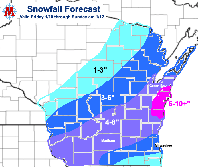
Are you ready to shovel!? Southern Wisconsin’s biggest winter storm of the season yet will bring heavy snow to a wide swath of the region beginning this evening. The heaviest snow will likely fall along the line from Platteville through Madison and extend to the North, including Green Bay. Locations along Lake Michigan will likely experience lake enhancement, producing heavier snowfall rates and allowing total accumulations to approach a foot in spots. Areas to the southeast, including Milwaukee, will unfortunately experience mixed precipitation for much of the storm, leading to significant icing and reduced snow totals.
The snow will come in two rounds, beginning this evening as a mix of precipitation enters the region from the southwest. Areas to the northwest will likely see all snow during this wave while the Milwaukee area will receive primarily freezing rain and sleet. Mixing with sleet may extend as far North and West as Madison at the onset of this round of precipitation. Precipitation will gradually switch over to snow towards the south as the storm progresses, continuing overnight before ending Saturday morning as a dry slot envelops the area. Accumulations will likely total 2-3 inches during this period with less to the North and West of the area of heaviest snow, and considerably less in areas that see primarily ice and mixed precipitation.
Round two will begin Saturday evening as heavy snow returns to the area. Snowy and windy conditions will create hazardous travel conditions over night into Sunday morning when snow will end (for real this time). In addition to dangerous travel conditions some power outages are likely, especially in the Milwaukee area, as the combination of ice, wet snow, and strong winds will strain power lines and trees.
Plan accordingly and stay aware of forecast updates to help minimize impacts to you and your family. This should be a pretty nice snowstorm for much of the area. If you don’t happen to be as excited about the prospect of a big snowstorm as I am, there is still a silver lining. Lambeau Field should be in full frozen tundra mode for Sunday night, strengthening the Packers home field advantage and further proving that REAL football teams don’t play in domes.
